Showing posts with label Utah. Show all posts

Saturday, November 15, 2014

Differently monumental, part 1

I became quite interested in memorials (especially war memorials) before and during my time in London in 2008.

So I couldn't help but be reminded of these artificial structures when we visited a couple of particularly monumental sites in the Four Corners area. First up is a wonderful little drive not far from Mexican Hat, Utah: Valley of the Gods.


It's not completely a slam-dunk to drive through this area; the road isn't paved, and although it was in good shape for most of its 17 miles, there were a few rather exciting wash-outs that were somewhat challenging.

we were very proud of the way our little van performed on a less-than-perfect road
But the scenery was worth the chances we took with our low-clearance vehicle.

As I hope you'll agree, there was so much photogenicity in this small area, it was very hard to stop taking pictures! And hard to find adequate words to describe the scenery...so I will let the pictures do most of the talking...

this was our favorite set of features...

...but there were so many to choose from!

the distant scenery was as sweet as the close-ups


the [mostly nice] road


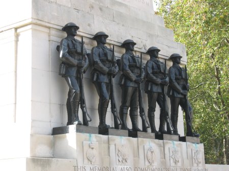
Here's final look at that favorite feature, which put me so in mind of one in London...separated at birth?

Valley of the Gods "guards"

Horse Guards memorial
Next time I'll finish up my posts about this wonderful trip with a look at some more famous Four Cornets monuments.

Saturday, November 8, 2014

Naturally beautiful bridges

Since we had just thoroughly enjoyed watching "The Roosevelts" on PBS before taking our trip out west, it was kind of cool to visit a national monument that crazy Teddy personally set aside.

Kachina Bridge
Natural Bridges National Monument is just a hop, skip, and a jump from our post-paddling base in Mexican Hat, Utah. So although we were disappointed that we couldn't make it to the more distant of Utah's many attractions, we were glad that this one was within reach.

The major attractions here (in addition to stargazing, which we were really disappointed not to be able to enjoy) are the three bridges carved out by the occasional streams that flow through White and Armstrong Canyons. The picture above is of the middle bridge of the three.

We only had time to hike at one of the bridges, the first one on the loop, Sipapu. Here's how it looks from the viewing ledge about half-way down the trail (which is where I stopped):


Henry hiked all the way down to the bottom, and got some great photos from that vantage point, like this one...


...while I got pictures of him 'way down there, in the "keyhole" made by the bridge (the red line will sort of show you where he is in this picture:


The main reason I didn't make the trek down was that I didn't want to have to climb back up the steep trail. But I also wanted to spend some more time on the fabulous Ledge Viewpoint...what an amazingly beautiful rock formation! Here's what it looks like from near the beginning of the trail...


...and here it is from a viewpoint near the end of the ledge. That tiny figure is Henry, just about to embark on his descent to the canyon floor...Thanks for providing the scale, dear!


I had a great time sitting up there, taking in the scenery, while he once again proved to be the more energetic member of our little partnership.

To give you an idea of how much hiking is involved here, this is a shot looking back up at the overlook, from the viewing ledge. You might be able to see tiny dots that are people up there, if you click on the image to enlarge it:


There was one more bridge to see in the park, Owachomo. It's the oldest of the three, and therefore the most slender (from more erosion):


This one's probably the most beautiful of the three, too, and Henry really wanted to hike down to it, but it was getting too late. We just didn't have enough time to do justice to this marvelous scenery!

In addition to the bridges, there are also archaeological sites in the park. Here's the most easily viewable, Horsecollar Ruin (the name is taken from the structure on the far right):


We weren't surprised to find evidence of early human habitation here, given what we learned on this trip about how advanced the cultures were that settled this region, and where they liked to build their little towns.

In addition to anthropology, you can also learn all kinds of geology, obviously, out here. For example, we wondered about the difference, if any, between arches and bridges. (Long-time readers might remember my trip a few years ago to Arches National Park, further north in Utah.) And the rangers at the Natural Bridges visitors' center were happy to oblige with this information.

Arches, astonishingly enough, are made by wind erosion, whereas bridges, like those you see here, were made by the—still amazing, but slightly more believable—process of water erosion. To paraphrase a popular blog, "IFL Geology!"

Tuesday, November 4, 2014

Rocky playground

When our kids were younger, one of our favorite vacation spots was Enchanted Rock, not far from here and so much fun to go climbing all over.

I admit I enjoyed the rock clambering (not really rock climbing, although there's always a lot of that going on there, too; clambering is a lot less stressful) just as much as the kids did. And I still do!


So I had a blast at Muley Point, near the Moki Dugway in Utah (I showed you some scenery from there in this post).

In addition to the great scenery, there were all these really wonderful rocks to clamber around. I felt like a 10-year-old!


Henry enjoyed it, too...


There were these great, photogenic, desert trees...


...as well as some evidence of the area's recent rains...


But the rocks are the stars! (along with the scenery, of course)


In addition to the Goosenecks that I told you about last time, and that you can see in the photo above, there was more great background scenery for the Muley Point rocks to pose in front of...


In fact, the subject of my next post, Valley of the Gods, can be partially seen in the picture just above and in the one below. No clambering rocks there, but some pretty scenic specimens...stay tuned!

Saturday, November 1, 2014

Mother [of all] Goosenecks

You really have to see the entrenched meander that is the San Juan Goosenecks to believe it. (Look up "entrenched river" in Wikipedia, and it's essentially the definition given.)


Single photos just can't capture its scale, beauty, and alienness at all. And even the panoramic shot, above, that Henry took still falls short. (Click on it to see the full image.) This video might do a little better, but you still really should visit Goosenecks State Park for yourself and see it.

The park is just 10-15 minutes from Mexican Hat, and we headed there shortly after checking in to our post-paddle motel (but after a shower and a quick nap!).


Unfortunately, the late afternoon sun isn't the best for photographing this amazing scenery, but we couldn't help taking lots of pictures anyway.


It's hard to believe that's just one river's work down there! Two years ago, when Henry and his buddies extended their San Juan paddle to include this section (almost 60 more miles and 5 more nights!) they looked up here and saw tiny figures at the State Park taking in this view. But we didn't see any tiny boats down there this time, much to our disappointment.

We did get to see the Goosenecks again, from another vantage point, the next day.

After a rather too-exciting drive through the Valley of the Gods (pix from here later) we climbed the Moki Dugway, which is a pretty exciting road, too...


From the top of Cedar Mesa, you can take a little spur off the main road and get to Muley Point, which is a really, really fun place to explore. I'll have more pictures from here in my next post, but today I wanted to focus on the Goosenecks view that you get from this vantage point. 


You can't see down into the meander as well here as from the state park, but as a panoramic vista, the view is pretty spectacular. (The little tan ribbon in the photo above is a tributary streambed; when it's running there must be quite a waterfall down to the river!)


What amazing, amazing scenery! I'm not too surprised, upon reflection, that we ran into so many European tourists, not to mention folks from all over the U.S., at these various stops. (My license plate count came close to the numbers for Montana, even though we didn't hit any national parks on this trip.) You just can't find scenery like this anywhere else on planet Earth, imho.

Although we suspect that one of the main draws for these visitors, especially the rich Europeans, was what you can see in the background of this shot, looking over the top of the Goosenecks at Muley Point:


It's the most famous stretch of rock formations in this area, and, yes, we did visit it. I plan to finish up my series of posts with that excursion, though, so you'll have to wait a while to get a closer look.

Saturday, October 25, 2014

More ancient art & architecture

Last time I gave you a show-and-tell of the fascinating rock art and cliff dwellings we saw on our San Juan paddling trip.

But Henry and I didn't want those four days to be our entire desert southwest vacation. We spent a few days before, and a few after, touring some other wonderful places in that area. If you look at a recreation map of the Four Corners area (referring to the meeting of Colorado, Utah, Arizona, and New Mexico) it's astonishing how many wonderful sites are in relatively close proximity. We didn't have time to see them all, but we crammed as much into our "extra time" as we could...in the process visiting all four states and, technically, another "country"* as well.

Our first stop was at Canyon de Chelly National Monument in Arizona, which we'd heard glowing reports of from many quarters. We weren't disappointed in its scenery, which I'll review for you in upcoming posts. But, to finish up with the ancient art theme, I'll tell you first about the cliff dwellings we saw there: gorgeous examples of domestic architecture, circa 1100.

White House ruin
This fabulous site is the only one that you can hike to yourself in CdeC (other points of interest in the Canyon require a Navajo guide, and although we wanted to take one of these longer trips, we just didn't have time).

This shot can give you a better idea of the scale of the structures—it was a large settlement!—as well as illustrating a modern cultural phenomena: jewelry vendors.


More recent building has taken place along the trail, too, making the hike much more doable than it would have been without these improvements. Here's one of two tunnels carved through inconveniently-placed rock outcroppings:


Overall the hike was lots of fun, with photo opps galore all the way down to the Canyon floor and back up, and I'll show you more of these views in a later post. 

The White House ruin is on the south side of the canyon; on the north side is another impressive structure that we saw from a distance: Antelope House. Can you find it in this panoramic shot?


Spotting these cleverly-positioned structures across the canyon is a skill you have to work at a little, but once you get the hang of where to look it comes a little easier. Here's a zoom shot that shows Antelope House in more detail:


Incidentally, at a couple of the overlooks in CdC, they've implemented a very ingenious low-tech device to help people find the ruins (I'm glad to know that I'm not the only one who has difficulty with this!). There are metal tubes mounted in such a way that they point right to the ruins. Thanks, CdC! These should be required at overlooks everywhere.


After our paddling adventure, another national monument was on our itinerary. This one is in Utah, Natural Bridges NM. In addition to the emponymous natural rock features, they also have an impressive cliff dwelling, Horse Collar ruin. Test your new dwelling-finding skills on the photo below:


Unfortunately, we had even less time at Natural Bridges than Canyon de Chelly and were only able to do one of their hikes, and it didn't involve a cliff dwelling. More about that scenery, though, later.

(Another bummer from our time crunch was having to missing an astronomy program at NBNM, which was the first designated International Dark Sky Park. Such a cool claim to fame! And what makes it worth another visit sometime.)

The amazing abundance of archaeological sites in this area means that not all of them are in these nationally-protected areas. There were a few just off Highway 95 between Natural Bridges and Blanding, Utah. Unfortunately, we only had time to stop at one (note the low sun in the photo): Mule Canyon ruin. As you see from the link, there is more to it than what we saw by the roadside (where the structures are partially restored) but, again, time was working against us:


As interesting as the cultural sites are, we were probably more overwhelmed by the natural scenery of the Four Corners region. I'll spend the next few posts showing you some of these gorgeous and iconic vistas.

*A good-sized chunk of this area (especially in Utah, Arizona, and New Mexico) is in the Navajo Nation's territory, as any reader of Tony Hillerman's books can tell you. This includes Canyon de Chelly, the left bank of the San Juan during our paddle, and other sites I'll show you later, such as Monument Valley. So, in a strictly administrative law sense, we did visit another country on this trip!

Thursday, October 23, 2014

San Juan River: ancient art & architecture

One of the big draws of the section of the San Juan that we paddled is its abundance of archaeology. Although the high water prevented us from stopping to view some of the more famous rock art collections (namely the panels at Butler Wash), we still saw plenty.


It was such fun visiting these sites and walking along a cliff when, bang! all of sudden there was a work of art several hundred, perhaps even a thousand, years old! It does take a little eye-training to be able to spot some of these figures, but it's well worth it.

I couldn't help but be reminded, when looking at these artistic creations, of Kim Stanley Robinson's wonderful, wonderful novel Shaman, that I read last year. The rock art we saw wasn't as ancient as that which inspired KSR, but it's old enough that whoever created it seems, initially, to have to be completely alien to us. 

But, then, you see the art, and respond to it. Which means that these ancient peoples must not have been so different from 21st-century humans after all. We had so much fun discovering, and trying to interpret, these wonderful images and structures.


(Henry's camera got much better photos of these fascinating artifacts, and he's generously let me use some in this post.)

The items we're excited about in the photos above are petroglyphs, which were made by carving into the outer layer of a rock face, often made up of "desert varnish." Since this stuff is very common on exposed rock faces all over the southwest, and since, even given the area's dryness and overall inhospitable-ness, all kinds of indigenous peoples have lived here...well, there are a lot of petroglyphs to see. 

note the Kokopelli figure, left of the big man
All of the photos so far were taken on our hike to see the Moki steps on our first day of paddling. These steps are features that are also common in the desert, usually near cliff dwellings. The residents would use them, we surmise, to get up and down from their well-protected buildings...well-protected since it would take pretty strong and agile climbers to surprise you by climbing up these steps!

we were not able to see the ruins that are probably in the alcove at the top of the steps
Here is a closer look at this ingenious "ladder":


I was also intrigued by another set of holes, much smaller, near the steps. What could these have been for? Sorry I didn't include something for scale in the photo, but as I recall, each hole was about nickel-quarter-sized.


Our first night's campsite was chosen because of its proximity to the River House ruin, where we spent a delightful morning exploring. Here's the main ruin, snuggled up nicely on a wide ledge, under a convenient overhang of rock...


Not only was the ruin itself fun to wander around in (we were careful not to climb on the walls or otherwise disturb things, but the regulations still allow plenty of ways to explore the site)...

Cynthia and Henry enjoying the walk-through-museum
...but there was rock art here, too, in addition to the building. You might be able to see this pictograph high on the wall in the photo above...


By the way, one of the many things I learned on this trip was the difference between petroglyphs and pictographs, terms which had always confused me. The snake (or is it the river?) above is a pictograph because it's painted on the rock surface, rather than incised upon it, like the petroglyphs I showed you before.

Here's some more:


Down the ledge a ways is an "outbuilding," what's called the "granary." What a gorgeous piece of workmanship! Not quite on the same scale as the Inkas, but it did remind me of the stonework we saw in the Andes.


One of the most archaeology-rich areas we planned to visit was up Chinle Creek. However, the creek was responding to a lot of rain upstream and we couldn't cross it to get to the sites on the other side. (We found out later that it was peaking just about the time we were there...at about 200 times its normal flow!)

However, we had a very pleasant hike on the near side of the creek (you can see a lot of the naturally gorgeous and interesting rocks we saw in this post) and Henry, intrepid explorer, did find a way to get close enough to the sites to get some good pictures:

cliff dwelling across the creek

"baseball man" pictograph
And, we saw yet another manifestation of indigenous art...pottery shards. These lovely items were littering the ground at the end of a small arroyo, no doubt washed down from middens higher up...


Our final petroglyph stop was actually right where we started. There's a very impressive panel at Sand Island, near Bluff, where we had launched several days before. Since we were much too busy then to take the time to do an art walk, Henry and I made sure we stopped by on our way home...

the guy on the wall is one of the largest figures we saw anywhere

We were able to get much more up close and personal to the rock art and ruins along the San Juan than we were at other points on our journey, but we did see some amazing archaeology at Canyon de Chelly and Natural Bridges National Monuments, and I'll show you those sites in my next post.

BTW, I've put almost all of my San Juan pictures up in a Flickr set, if you haven't seen enough of this amazing scenery.