Saturday, November 15, 2014

Differently monumental, part 1

I became quite interested in memorials (especially war memorials) before and during my time in London in 2008.

So I couldn't help but be reminded of these artificial structures when we visited a couple of particularly monumental sites in the Four Corners area. First up is a wonderful little drive not far from Mexican Hat, Utah: Valley of the Gods.


It's not completely a slam-dunk to drive through this area; the road isn't paved, and although it was in good shape for most of its 17 miles, there were a few rather exciting wash-outs that were somewhat challenging.

we were very proud of the way our little van performed on a less-than-perfect road
But the scenery was worth the chances we took with our low-clearance vehicle.

As I hope you'll agree, there was so much photogenicity in this small area, it was very hard to stop taking pictures! And hard to find adequate words to describe the scenery...so I will let the pictures do most of the talking...

this was our favorite set of features...

...but there were so many to choose from!

the distant scenery was as sweet as the close-ups


the [mostly nice] road


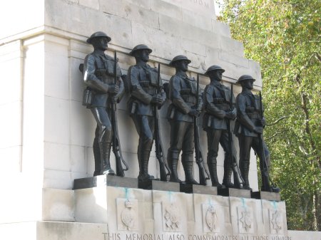
Here's final look at that favorite feature, which put me so in mind of one in London...separated at birth?

Valley of the Gods "guards"

Horse Guards memorial
Next time I'll finish up my posts about this wonderful trip with a look at some more famous Four Cornets monuments.

Thursday, November 13, 2014

A Texas interlude

It would take something pretty stupendous to distract me from finishing up my posts about our trip to the Four Corners.


And then, heavy rains last week provided one of the few excursions that could do this. We were able to paddle the upper Guadalupe for the first time in almost a year! This opportunity—both for boating and for blogging about it—simply could not be passed up.

It wasn't surprising that we had a bumper crop of paddlers show up on such a gorgeous day for the trip, starting at the Zoeller Lane bridge...


And we had a wonderful time. The water level, though paddle-able, wasn't high enough for many thrills, but there was a nice little chute after lunch. Here are Joline, and then Jon, making the transit look easy...


The river was beautiful and the water not too cold (a blessing for our few swimmers). But the trees were the real stars of the show. I couldn't stop taking pictures of the stately cypress, just starting to turn their autumn russet...

camera looking straight up

cypresses changed and changing

such a handsome lineup!

fall colorful
Then there are the usual great rockfaces one finds along the Guadalupe...costumed with fall vine foliage now, to make them extra photogenic:


And, in the Texas Hill Country, even the dead trees are beautiful!


Is there any reason these people wouldn't be happy to be here?! 

Saturday, November 8, 2014

Naturally beautiful bridges

Since we had just thoroughly enjoyed watching "The Roosevelts" on PBS before taking our trip out west, it was kind of cool to visit a national monument that crazy Teddy personally set aside.

Kachina Bridge
Natural Bridges National Monument is just a hop, skip, and a jump from our post-paddling base in Mexican Hat, Utah. So although we were disappointed that we couldn't make it to the more distant of Utah's many attractions, we were glad that this one was within reach.

The major attractions here (in addition to stargazing, which we were really disappointed not to be able to enjoy) are the three bridges carved out by the occasional streams that flow through White and Armstrong Canyons. The picture above is of the middle bridge of the three.

We only had time to hike at one of the bridges, the first one on the loop, Sipapu. Here's how it looks from the viewing ledge about half-way down the trail (which is where I stopped):


Henry hiked all the way down to the bottom, and got some great photos from that vantage point, like this one...


...while I got pictures of him 'way down there, in the "keyhole" made by the bridge (the red line will sort of show you where he is in this picture:


The main reason I didn't make the trek down was that I didn't want to have to climb back up the steep trail. But I also wanted to spend some more time on the fabulous Ledge Viewpoint...what an amazingly beautiful rock formation! Here's what it looks like from near the beginning of the trail...


...and here it is from a viewpoint near the end of the ledge. That tiny figure is Henry, just about to embark on his descent to the canyon floor...Thanks for providing the scale, dear!


I had a great time sitting up there, taking in the scenery, while he once again proved to be the more energetic member of our little partnership.

To give you an idea of how much hiking is involved here, this is a shot looking back up at the overlook, from the viewing ledge. You might be able to see tiny dots that are people up there, if you click on the image to enlarge it:


There was one more bridge to see in the park, Owachomo. It's the oldest of the three, and therefore the most slender (from more erosion):


This one's probably the most beautiful of the three, too, and Henry really wanted to hike down to it, but it was getting too late. We just didn't have enough time to do justice to this marvelous scenery!

In addition to the bridges, there are also archaeological sites in the park. Here's the most easily viewable, Horsecollar Ruin (the name is taken from the structure on the far right):


We weren't surprised to find evidence of early human habitation here, given what we learned on this trip about how advanced the cultures were that settled this region, and where they liked to build their little towns.

In addition to anthropology, you can also learn all kinds of geology, obviously, out here. For example, we wondered about the difference, if any, between arches and bridges. (Long-time readers might remember my trip a few years ago to Arches National Park, further north in Utah.) And the rangers at the Natural Bridges visitors' center were happy to oblige with this information.

Arches, astonishingly enough, are made by wind erosion, whereas bridges, like those you see here, were made by the—still amazing, but slightly more believable—process of water erosion. To paraphrase a popular blog, "IFL Geology!"

Tuesday, November 4, 2014

Rocky playground

When our kids were younger, one of our favorite vacation spots was Enchanted Rock, not far from here and so much fun to go climbing all over.

I admit I enjoyed the rock clambering (not really rock climbing, although there's always a lot of that going on there, too; clambering is a lot less stressful) just as much as the kids did. And I still do!


So I had a blast at Muley Point, near the Moki Dugway in Utah (I showed you some scenery from there in this post).

In addition to the great scenery, there were all these really wonderful rocks to clamber around. I felt like a 10-year-old!


Henry enjoyed it, too...


There were these great, photogenic, desert trees...


...as well as some evidence of the area's recent rains...


But the rocks are the stars! (along with the scenery, of course)


In addition to the Goosenecks that I told you about last time, and that you can see in the photo above, there was more great background scenery for the Muley Point rocks to pose in front of...


In fact, the subject of my next post, Valley of the Gods, can be partially seen in the picture just above and in the one below. No clambering rocks there, but some pretty scenic specimens...stay tuned!

Saturday, November 1, 2014

Mother [of all] Goosenecks

You really have to see the entrenched meander that is the San Juan Goosenecks to believe it. (Look up "entrenched river" in Wikipedia, and it's essentially the definition given.)


Single photos just can't capture its scale, beauty, and alienness at all. And even the panoramic shot, above, that Henry took still falls short. (Click on it to see the full image.) This video might do a little better, but you still really should visit Goosenecks State Park for yourself and see it.

The park is just 10-15 minutes from Mexican Hat, and we headed there shortly after checking in to our post-paddle motel (but after a shower and a quick nap!).


Unfortunately, the late afternoon sun isn't the best for photographing this amazing scenery, but we couldn't help taking lots of pictures anyway.


It's hard to believe that's just one river's work down there! Two years ago, when Henry and his buddies extended their San Juan paddle to include this section (almost 60 more miles and 5 more nights!) they looked up here and saw tiny figures at the State Park taking in this view. But we didn't see any tiny boats down there this time, much to our disappointment.

We did get to see the Goosenecks again, from another vantage point, the next day.

After a rather too-exciting drive through the Valley of the Gods (pix from here later) we climbed the Moki Dugway, which is a pretty exciting road, too...


From the top of Cedar Mesa, you can take a little spur off the main road and get to Muley Point, which is a really, really fun place to explore. I'll have more pictures from here in my next post, but today I wanted to focus on the Goosenecks view that you get from this vantage point. 


You can't see down into the meander as well here as from the state park, but as a panoramic vista, the view is pretty spectacular. (The little tan ribbon in the photo above is a tributary streambed; when it's running there must be quite a waterfall down to the river!)


What amazing, amazing scenery! I'm not too surprised, upon reflection, that we ran into so many European tourists, not to mention folks from all over the U.S., at these various stops. (My license plate count came close to the numbers for Montana, even though we didn't hit any national parks on this trip.) You just can't find scenery like this anywhere else on planet Earth, imho.

Although we suspect that one of the main draws for these visitors, especially the rich Europeans, was what you can see in the background of this shot, looking over the top of the Goosenecks at Muley Point:


It's the most famous stretch of rock formations in this area, and, yes, we did visit it. I plan to finish up my series of posts with that excursion, though, so you'll have to wait a while to get a closer look.